Using satellites to identify floating plastic waste
Canadian Plastics
Research & DevelopmentA new technique developed by English researchers uses satellites to detect plastics floating on the sea surface, and distinguish it from naturally occurring floating materials such as seaweed.
A new technique that uses satellites to detect plastics floating on the sea surface has been developed by scientists at Plymouth Marine Laboratory (PML), a research institute in Plymouth, England.
The technique allows aggregated patches of plastics floating in coastal waters to be detected by European Space Agency’s Sentinel-2 satellites; and also to distinguish aggregations of plastic particles larger than 5mm – called macroplastics – from naturally occurring floating materials such as seaweed, driftwood, and foam, with an average accuracy of 86% across four case study sites, including one in Canada.
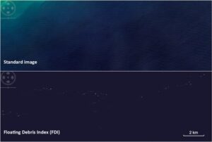
Top: enhanced “true colour” image of Ghanaian waters; bottom: suspected plastics become more visible by using the Floating Debris Index (FDI) in this satellite imagery generated from the European Space Agency. Photo Credit: Plymouth Marine Laboratory
This technical challenge, primarily funded by the Natural Environment Research Council’s ACCORD research program, is being hailed by PML as a first step towards developing an operational method of detecting floating plastic patches in waters all over the world.
The PML team ran high-resolution, multi-spectral optical satellite data of coastal waters through an algorithm tuned to highlighting objects floating on the ocean surface, creating the Floating Debris Index (FDI) for the Sentinel-2 Multi-spectral Instrument.
The next stage was to identify floating plastics. Thanks to a collaboration with the University of the Aegean, who shared information on deployed plastic targets for their new study into plastic litter, the team was able to know exactly what Sentinel-2 was “seeing” through the FDI, and was therefore able to build an optical signature for floating plastics. These known plastic detections were supplemented with validated plastics data detected after severe flooding in Durban, South Africa. Once the plastic signatures were established, the team then began the same process for such natural debris as driftwood, seaweed, and seafoam, which are likely to be mixed in with the plastic patches.
With the algorithm development and validation complete, the team began searching for plastics “in the wild”. Based on published studies and social media posts, they detected aggregations in two developed countries – Canada (Gulf Islands) and Scotland – and two developing countries – Ghana (Accra) and Vietnam (Da Nang).
Manually, they selected pixels that were suspected to be dominated by plastics – and across the four study sites, suspected plastics were successfully classified as plastics with an overall accuracy of 86% (Gulf Islands 100%, Accra 87%, Scotland 83%, and Da Nang 77%). Less accurate classification resulted from pixels not being sufficiently full with floating debris and a small proportion of suspected plastics being identified as sea foam.
The team plans to continue to refine the technique to further increase its accuracy in detecting floating plastic patches in turbid coastal waters and large river systems. “Plastic pollution is a global issue,” said Dr Lauren Biermann, Earth Observation Scientist at PML. “This method will hopefully provide a stepping stone for satellites and drones to be used to tackle the marine plastics problem at the end of the product lifecycle.”
Source: Plymouth Marine Laboratory